New technology uses optical and radar satellite data to map pasture
- 04/01/2016
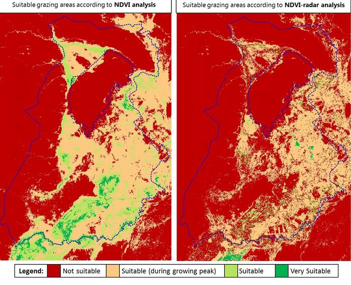
Suitable grazing areas identified by NDVI analysis alone and NDVI-radar analysis combined/ LTS International
As part of the BRACED programme, LTS International, working with Farm Africa, is developing a unique tool for monitoring vegetation cover changes. This semi-automated tool will be used by the programme to monitor changes in vegetation cover in remote rangeland areas of Afar Region, Ethiopia.
As part of BRACED, Farm Africa and Mercy Corps are implementing participatory rangeland management (PRM) in the pastoral areas of Afar and Somali regions. PRM empowers rangeland users to identify better ways to manage natural resources, to plan for more sustainable use of available grass and water, and improve pasture quality. The results of this process can be difficult to measure as typically they cover large areas in remote locations.
The RaVeN monitoring tool under development by LTS International aims to address this problem. This new tool makes the measurement of change in pasture quality a rapid and automated process by using freely available optical and radar satellite data in combination with meteorological data. The tool uses this data to compare the relative greenness of an area at different points in time, while discriminating between different vegetation classes and controlling for the effects of different rainfall levels. It therefore enables changes in pasture quality to be assessed and quantified.
In order to measure change and monitor the vegetation “greenness” in these rangeland areas, the LTS team developing the tool needed to overcome three challenges:
- First, understand the historical trends of vegetation “greenness” in the site of interest;
- Second, understanding the historical correlation between rainfall and the vegetation “greenness”;
- Third, understanding the relationship between vegetation “greenness” and the prevalence of invasive species or edible pasture.
To tackle the first challenge and measure vegetation “greenness” fifteen-years of historical satellite imagery was acquired from two different satellites - the Landsat and the Moderate Resolution Imaging Spectroradiometer (MODIS) sensors. This data covering the period 2000-2014 was combined and pre-processed to remove cloud coverage. The data was then used to compute the Normalised Difference Vegetation Index (NDVI), which measures the “greenness” of the land and is widely used as a proxy for vegetation in monitoring land cover changes. NDVI maps showing spatial and temporal changes of vegetation were produced for the project area at 30 meters resolution. An animation of the fifteen-year analysis can be seen online at http://t.co/PoIQev5Cm8.
In order to be sure that identified vegetation changes are a result of improved management rather than changes in weather, the tool must tackle the second challenge and take into account historical climatic conditions. By understanding the historical correlation between rainfall and NDVI in the project area, the tool will establish a baseline against which future observations can be compared. This work is still underway.
The final challenge emerged from the use of NDVI as an indicator of pasture quality. Unfortunately, NDVI does not distinguish between vegetation types, but for the tool to measure whether increases in “greenness” will improve livelihoods, differentiating between edible and non-edible vegetation is essential. The study area has large areas covered with the invasive species Prosopis juliflora, which has spread across nearly 1.2 million hectares in Afar Region alone. The Prosopis species is one of the most invasive in the world, and although it may offer other potential uses such as flour from its seed pods and charcoal and firewood production, it competes with other more palatable rangeland species for water and is inedible to cattle and sheep. Rangeland management plans frequently focus on clearance to reduce its coverage, so to monitor the true impacts of the programme, the tool needs to separate areas covered by these trees from those covered in edible pasture.
To solve this problem LTS International has used Radio Detection and Ranging (radar) remote sensing technology to integrate and complement the NDVI vegetation maps. Using the European Space Agency’s Sentinel-1 radar satellite data, a map of vegetation structure can be produced. This allows areas dominated by Prosopis juliflora to be clearly shown so that changes in the areas suitable for grazing can be monitored over time and insights into the spread and prevalence of Prosopis juliflora gained. Radar captures vegetation structure rather than just its reflective qualities (“greenness”), therefore it can be used to distinguish between smooth grassland and the taller shrub land or forest.
The RaVeN monitoring tool is currently being tailored for the project site. Some crucial next steps need to be carried out to gain the most effective information on rangeland quality:
- The regression between NDVI values and monthly precipitation data to assess the historical correlation between these two variables needs to be completed.
- Supported by Farm Africa, the LTS team will undertake fieldwork in early 2016 to collect ground-truthing data for the NDVI-radar analysis. Transects of different vegetation classes will be visited and data collected to calibrate and validate the remotely sensed imagery.
To complete the project baseline, ground-truthing data will then be analysed to identify which radar values are sensitive to which vegetation classes. This data will then be incorporated into the modelling of the NDVI analysis and baseline maps showing the quality of pasture available in areas under improved management will be produced.
Video
From camel to cup
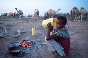
From Camel to Cup' explores the importance of camels and camel milk in drought ridden regions, and the under-reported medicinal and vital health benefits of camel milk
Blogs
As climate risks rise, insurance needed to protect development
Less than 5 percent of disaster losses are covered by insurance in poorer countries, versus 50 percent in rich nations
Disasters happen to real people – and it's complicated
Age, gender, ethnicity, sexual orientation and many more factors must be considered if people are to become resilient to climate extremes
NGOs are shaking up climate services in Africa. Should we be worried?
A concern is around the long-term viability of hard-fought development gains
The paradox of water development in Kenya's drylands
In Kenya's Wajir county, the emphasis on water development is happening at the expense of good water governance
Latest Photos


Tweets
© 2018 | Terms of Use
We welcome comments that advance the story through relevant opinion, anecdotes, links and data. If you see a comment that you believe is irrelevant or inappropriate, you can flag it to our editors by using the report abuse links. Views expressed in the comments do not represent those of Braced or its partners.