Armed with smartphones and boots, Niger youths map flood risks
- 29/09/2017

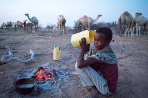
An OpenStreetMap “investigator” plots rice fields in a district of Niamey, Niger, September 9, 2017. Thomson Reuters Foundation/Morgane Le Cam

NIAMEY - Fatima Alher watches her step, careful not to sink knee-deep in the water flooding the rice fields of Kirkisoy, a neighbourhood in Niger's capital.
Her colleagues help lift her over the biggest puddles – a task complicated by the fact that they barely take their eyes off their smartphones.
"Never without a phone, that's our motto," Alher says, frantically typing on her screen.
In one of the world's poorest countries, widespread flooding has killed at least 56 people and destroyed thousands of homes since the rainy season began in June, according to the interior ministry.
Efforts to rebuild flood-hit areas are not progressing fast enough, residents complain.
But since July, a team of 20 "investigators" from OpenStreetMap Niger – a community of students and young professionals who are developing a digital map of the country – have been plotting flood-prone areas on their smartphones in two of Niamey's districts.
"Flooding devastates the country every year, and yet no effort has been made to chart the most vulnerable areas," Alher, a geography student and leader of the group, told the Thomson Reuters Foundation.
Using GeoODK, an app that allows users to collect geo-referenced information, the researchers gather details such as the number of residents and buildings, any construction materials used and the location of electric poles.
"By the end of August we had drawn up a list of over 15,000 properties and buildings," Alher proudly explained. "We then send the data to the interior ministry, so it can better target its relief efforts in times of flooding."
The three-month initiative is managed by the government Disaster Risk Management and Urban Development Project, and funded by the World Bank.
LIMITING DAMAGE
Standing in the middle of his flooded rice fields, Mohamed Moktar Innocent says he has given up planting anything this season, and expects further flooding to wipe out what little harvest he has left.
"I have lost over 160,000 CFA francs' ($287) worth of rice in the past six months," he sighed.
"I can't even repay the loan I took out to invest in my rice fields – but any investment is useless anyway. The floods destroy everything."
Researchers from OpenStreetMap researchers have plotted his rice fields, which Innocent hopes will allow him to understand how vulnerable his land is to flooding and when it might be safe to start planting.
Once the data has been collected and analysed, the mapping project aims to alert populations living in particularly flood-prone areas.
"The data hosted on OpenStreetMap will be publicly available, so programmers can use it to build apps to share information with vulnerable populations," explained Alher.
WARNING SYSTEM
The OpenStreetMap project says it is the first of its kind to map flood-prone areas in Niger, but other initiatives in the area aim to prevent flooding and minimise any damage.
One of them has set up an information network among 136 villages, with field agents regularly traveling between flood- or drought-hit zones and the capital.
The initiative, led by aid agency Catholic Relief Services, is part of the Building Resilience and Adaptation to Climate Extremes and Disasters (BRACED) programme, funded by the UK Department for International Development.
"Each village has set up a disaster committee," said Ali Issaka Mamane, a project manager for CRS.
"Whenever a disaster strikes, the committee secretary fills in a survey and sends it through one of our vehicles to our office and the government in Niamey, so we know exactly what is needed in terms of relief efforts."
The project also shares climate and weather information through its field agents and local radio stations to inform communities about weather shocks and convince them to evacuate their homes if the risks are high.
Mamane hopes to make the system more efficient, however.
"It still takes us two days to send the surveys by car from the most remote areas of Niger to the capital," he said. "We wanted to issue text alerts but failed to reach an agreement with the telecom operator, who was too expensive."
In the meantime, the OpenStreetMap researchers are moving onto another area of the capital.
"We're young and keen to help," said one of them, shaking mud off his boots.
"The working conditions are tough, but worth it. And if we don't do this job, who will?"
Video
From camel to cup
From Camel to Cup' explores the importance of camels and camel milk in drought ridden regions, and the under-reported medicinal and vital health benefits of camel milk
Blogs
As climate risks rise, insurance needed to protect development
Less than 5 percent of disaster losses are covered by insurance in poorer countries, versus 50 percent in rich nations
Disasters happen to real people – and it's complicated
Age, gender, ethnicity, sexual orientation and many more factors must be considered if people are to become resilient to climate extremes
NGOs are shaking up climate services in Africa. Should we be worried?
A concern is around the long-term viability of hard-fought development gains
The paradox of water development in Kenya's drylands
In Kenya's Wajir county, the emphasis on water development is happening at the expense of good water governance
Latest Photos


Tweets
© 2018 | Terms of Use
We welcome comments that advance the story through relevant opinion, anecdotes, links and data. If you see a comment that you believe is irrelevant or inappropriate, you can flag it to our editors by using the report abuse links. Views expressed in the comments do not represent those of Braced or its partners.